In British Columbia, many forestry roads were built in past decades on steep slopes using poor construction practices and then were often inadequately deactivated afterwards.
These locations may now pose landslide hazards which could lead to damage to people and surrounding areas. Their chance of occurrence will likely increase in the future due to projected increases in the frequency and severity of extreme rainfall events.
Today, there are over 36 000 kilometres of these “legacy” roads in B.C. on steep terrain, and classifying their hazards and risks requires terrain stability assessments that involve significant resources and expertise. To help address the challenge of completing assessments in a reasonable time on these legacy roads, a team of FPInnovations researchers designed a study to test a modelling-based approach to preliminary landslide hazard assessment.
The study involved developing a simple and approachable method that focused on hydrological rather than landslide modelling. This is an important simplification for the study, given that no adoption of modelling exists within terrain stability assessments done in B.C. (and North America) but some adoption does exist elsewhere in the world.
The researchers used a two-metre-resolution digital elevation model from the B.C. government’s Open LiDAR Data Portal to calculate hillslope, as well as a surface hydrology variable called specific catchment area (SCA). Points of concern were identified based on where high SCA values resulted from diversion and concentration of road drainage on steep terrain.
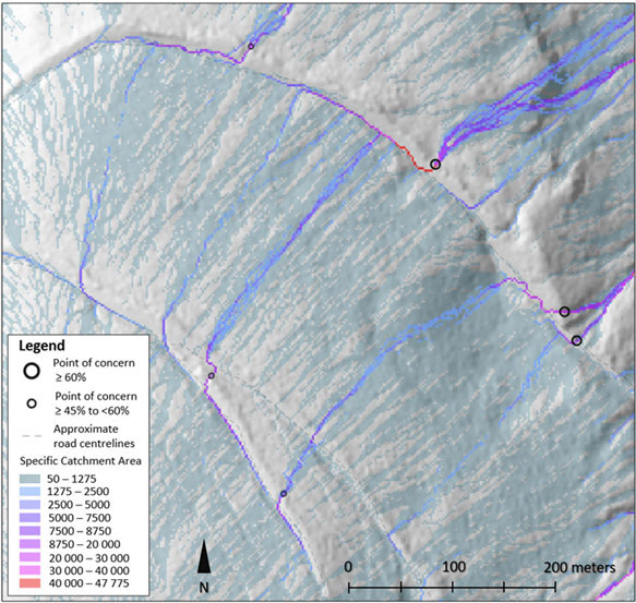 Accumulation of water along legacy roads results in high specific catchment area along flow path. Black circles denote points of concern for terrain instability.
The promising preliminary results of a hydrologically based legacy road hazard assessment opens many possibilities that will need improvement and validation of the approach. For example, testing if other ways of using slope, SCA, and possibly even simple soil information layer to identify points (or areas) of concern may produce better results. Other fundamental work is also needed, such as increasing the number of legacy roads analyzed, looking for additional visual indicators on the ground of unstable terrain as part of field work, determining whether a higher digital elevation model resolution may be useful, and considering the benefits of landslide mapping and how this could help calibrate interpretation of SCA values.
Once improved upon and optimized, the resulting method for assessing legacy road hazards should be able to rapidly assess large regions with LiDAR coverage. This or similar modelling approaches to identifying landslide hazards may prove useful for land managers needing to prioritize detailed terrain stability assessments within areas with legacy roads, and could provide additional insight to geoscientist and engineering professionals doing the assessments.
The Open LiDAR Data Portal is an initiative from the B.C. government to make its LiDAR and associated datasets available to the public. The province’s recent commitment to continue expanding high-density LiDAR coverage via the portal could allow preliminary terrain stability assessments for the regions or the entire province as part of prioritizing treatments of the most problematic legacy roads.
A report on this subject is available to the public. For more information, contact any of the report’s authors —
Source: FPInnovations